Файл:Karta över Uppsala, 1920, Nordisk familjebok.jpg
Повна роздільність (2509 × 2695 пікселів, розмір файлу: 1,08 МБ, MIME-тип: image/jpeg)
| Відомості про цей файл містяться на Вікісховищі — централізованому сховищі вільних файлів мультимедіа для використання у проектах Фонду Вікімедіа. |
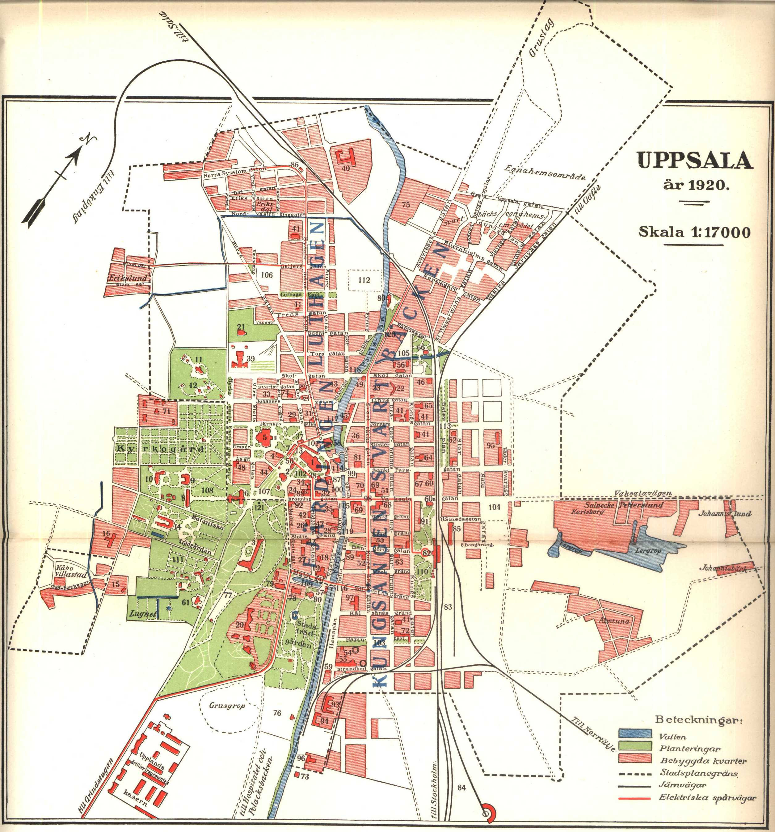
1. Domkyrkan. 2. Trefaldighetskyrkan. - 3. Slottet. - 4. Ärkebiskopshuset. - 5. Universitetshuset. - 6. Universitetsbiblioteket (Carolina rediviva). - 7. Gustavianum. - 8. Gamla Chemikum. - 9. Nya Chemikum. - 10. Fysiska byggnaden (Fysikum). - 11. Astronomiska observatoriet. - 12. Meteorologiska institutionen.- 13. Mineralogisk-geologiska institutionen (i gamla konsistoriehuset eller "Kuggis"). - 14. Botaniska institutionen med botaniskt museum och växthus. - 15. Växtbiologiska institutionen. - 16. Zoologiska institutionen - 17. Fysiologiska institutionen (Regnelleanum). - 18. Patologiska institutionen. 19. Anatomiska institutionen. - 20. Akademiska sjukhuset. - 21. Biologiskt museum jämte Victoriamuseet för egyptiska fornsaker. 22. Museet för nordiska fornsaker. 23. Linneanum. 24. Stockholms nations hus. - 25. Upplands nations hus. - 26. Gästrike-Hälsinge nations hus. 27. Östgöta nations hus.- 28. Västgöta nations hus. - 29. Södermanlands-Närkes nations hus. - 30. Västmanlands-Dala nations hus. -31. Smålands nations hus. -32. Göteborgs nations hus. - 33. Kalmar nations hus. 34. Värmlands nations hus. - 35. Norrlands nations hus. - 36. Gottlands nations hus. - 37. Vetenskapssocieteten. - 38. Skytteanum. - 39. Högre allmänna läroverket ("katedralskolan"). - 40. Folkskollärarseminarium. - 41. Folkskolor. - 42. Uppsala enskilda läroverk och privatgymnasium. - 43. Högre elementarläroverk för flickor. - 44. Lindska (flick-)skolan. .- 45. Fjellstedtska skolan. 46. Teknisk skola. - 47. Fackskola för huslig ekonomi. - 48. Blindskola. - 49. Arbetarinstitut (Fyrishall). - 50. Gamla katedralskolehuset och f. d. folkskollärarseminariet. 51. Rådhus. - 52. Postkontor och Riksbankens afdelningskontor. - 53. Telegraf- och rikstelefonstation samt Svenska landtmännens banks afdelningskontor. 54. Gasverk. - 55. Elektricitetsverk. 56. Brandstation. - 57. Vattenverk. - 58. Saluhall. - 59. Tullhus. - 60. Tingshus. - 60 a. Teater. - 61. Länscellfängelse. 62. Österplans kyrksal. - 63. Baptistkapell. - 64. .Metodistkapell. 65. Missionshus. - 66. Mikaelskapellet. - 67. Sparbank. - 68. Upplands enskilda bank. 69. Mälar-provinsernas enskilda banks afd:skontor A och B. - 70. Svenska handelsbankens afd:skontor samt Stockholmstelefons station. - 71. Epidemisjukhus. - 72. Samarithemmet. - 73. Gillbergska barnhusinrättningen. 74. Borgerskapets gubb- och änkhus. 75. Invaliden (försörjningsinrättning). - 76. Idrottsplats. - 77. Lekplan. - 78. Studentkårens gymnastikhus. -79. Tennispaviljong. - 80. Kallbadhus. - 81. Varmbadhus. 82. Järnvägscentralstation. 83. Bangård. - 84. Godsbangård. - 85. Östra stationen. - 86. Norra stationen. - 87. Uppsala Gille. - 88. Stadshotellet ("Gästis"). - 89. Grand hotell Hörnan. - 90. Flustret. 91. Rullan. - 92. Uppsala fabriks- och handtverksförenings hus. - 93. Ångkvarn. - 94. Jästfabrik. - 95. A.-b. Nymans verkstäder. 96. Tullgarns mekaniska verkstad. 97. H. Gahns aseptin- och amykos-a.-b:s fabrik. - 98. Stortorget. - 99. Gamla torget. - 100. Fyristorg (f. d. Vedtorget). 101. S:t Eriks torg. 102. Riddartorget. - 103. Kungsängs torg. 104. Vaksala torg. - 105. Svartbäcks torg. - 106. Luthags torg. - 107. Odinslund. - 108. Carolinaparken. - 109. Slottsdammen ("Svandammen"). - 110. Järnvägsparken. 111. Trädskola.- 112. Koloniträdgårdar. - 113. Österplan. - 114. Dombron. - 115. Nybron. - 116. Islandsbron. -
117. Järnbron'. 118. Haglunds bro. - 119. Västgötaspången. 120. Luthagsspången. 121. Gunnar Wennerbergsstatyn.Source: Nordisk familjebok (1920), vol.30, Uppsala [1] and in colour via Swedish Wikipedia
This image was first published in the 1st (1876–1899), 2nd (1904–1926) or 3rd (1923–1937) edition of Nordisk familjebok. The copyrights for that book have expired and this image is in the public domain, because images had no named authors and the book was published more than 70 years ago.
|
This image (or other media file) is in the public domain because its copyright has expired and its author is anonymous.
This applies to the European Union and those countries with a copyright term of 70 years after the work was made available to the public and the author never disclosed their identity. Important: Always mention where the image comes from, as far as possible, and make sure the author never claimed authorship. |
 | |
 |
Note: In Germany and possibly other countries, certain anonymous works published before July 1, 1995 are copyrighted until 70 years after the death of the author. See Übergangsrecht. Please use this template only if the author never claimed authorship or their authorship never became public in any other way. If the work is anonymous or pseudonymous (e.g., published only under a corporate or organization's name), use this template for images published more than 70 years ago.
For a work made available to the public in the United Kingdom, please use Template:PD-UK-unknown instead.
|
Журнал завантажень локального файлу
- 19 februari 2004 kl.03.50 . . Den fjättrade ankan (Diskussion | Bidrag) . . 2509x3429 (982 740 bytes) (från Nordisk familjebok)
Історія файлу
Клацніть на дату/час, щоб переглянути, як тоді виглядав файл.
| Дата/час | Мініатюра | Розмір об'єкта | Користувач | Коментар | |
|---|---|---|---|---|---|
| поточний | 15:14, 17 жовтня 2008 | | 2509 × 2695 (1,08 МБ) | Ogre | reupload because left upper border was cropped too |
| 15:10, 17 жовтня 2008 |  | 2479 × 2675 (1,71 МБ) | Ogre | cropped | |
| 00:10, 26 липня 2006 |  | 2509 × 3429 (960 КБ) | Lokal Profil | {{en|Map of Uppsala, Sweden, 1920}} {{sv|Karta över Uppsala (1920)<br> 1. Domkyrkan. 2. Trefaldighetskyrkan. - 3. Slottet. - 4. Ärkebiskopshuset. - 5. Universitetshuset. - 6. Universitetsbiblioteket (Carolina rediviva). - 7. Gustavianum. - S. Ga |
Використання файлу
Така сторінка використовує цей файл:
Глобальне використання файлу
Цей файл використовують такі інші вікі:
- Використання в en.wikipedia.org
- Використання в it.wikipedia.org
- Використання в nl.wikipedia.org
- Використання в pl.wikipedia.org
- Використання в ru.wikipedia.org
- Використання в sv.wikipedia.org