Файл:Carte Hollande 1843.jpg

Повна роздільність (2400 × 3235 пікселів, розмір файлу: 3,66 МБ, MIME-тип: image/jpeg)
| Відомості про цей файл містяться на Вікісховищі — централізованому сховищі вільних файлів мультимедіа для використання у проектах Фонду Вікімедіа. |
Опис файлу
| Опис |
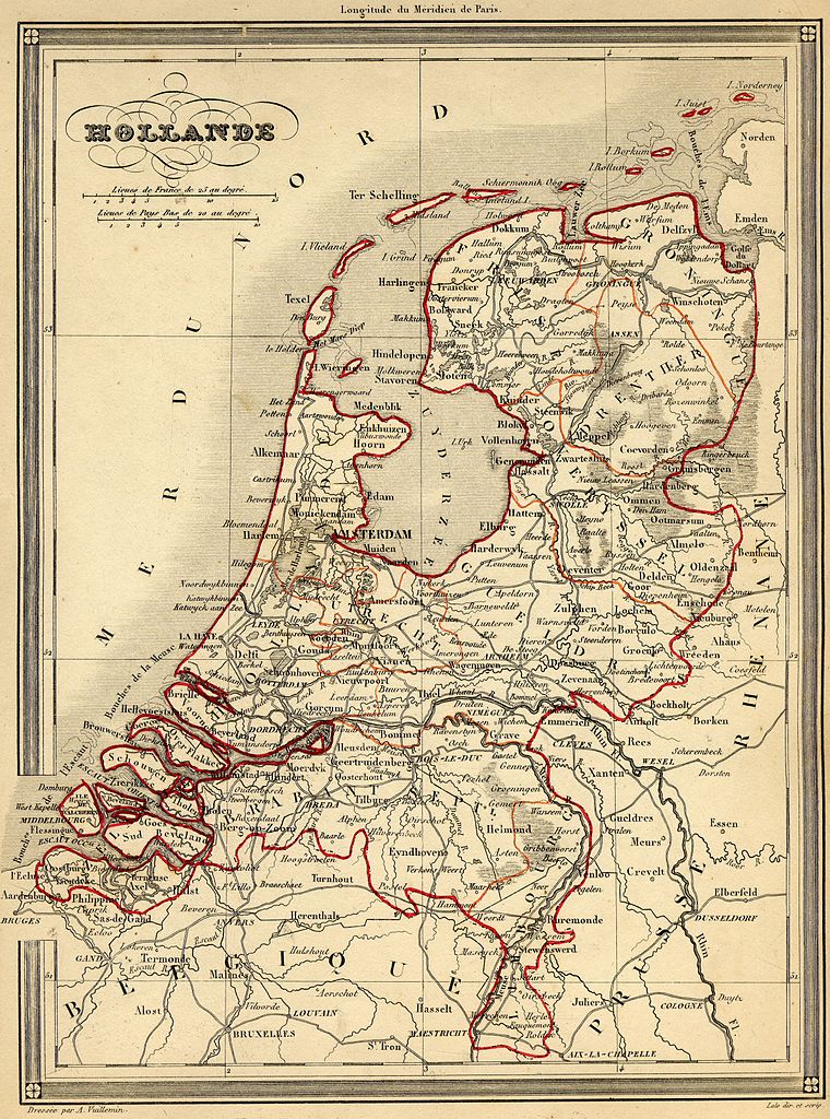
Français : Carte géographique ancienne des Pays-Bas (wp-FR) avec noms en français dressée par le géographe Alexandre Vuillemin en 1843 extraite de son “Atlas universel de géographie ancienne et moderne à l'usage des pensionnats”. Le titre original de cette carte est “Hollande”.
Sur cette carte de 1843, la rectification de frontière de 1839 transférant le Limbourg oriental et Maastricht de la Belgique aux Pays Bas est intégrée. Cet atlas était initialement monochrome mais son premier propriétaire a réhaussé manuellement en couleur les frontières ou limites administratives.English: French map of the Netherlands (wp-EN). Made by Alexandre Vuillemin and taken from his "Atlas universel de géographie ancienne et moderne à l'usage des pensionnats", 1843. |
| Час створення | |
| Джерело | |
| Автор | Alexandre Vuillemin (reproduit par histoirepostale.net) |
Ліцензування
This image is in the public domain because it is a mere mechanical scan or photocopy of a public domain original, or – from the available evidence – is so similar to such a scan or photocopy that no copyright protection can be expected to arise. The original itself is in the public domain for the following reason:
This tag is designed for use where there may be a need to assert that any enhancements (eg brightness, contrast, colour-matching, sharpening) are in themselves insufficiently creative to generate a new copyright. It can be used where it is unknown whether any enhancements have been made, as well as when the enhancements are clear but insufficient. For known raw unenhanced scans you can use an appropriate {{PD-old}} tag instead. For usage, see Commons:When to use the PD-scan tag.  | ||||
Історія файлу
Клацніть на дату/час, щоб переглянути, як тоді виглядав файл.
| Дата/час | Мініатюра | Розмір об'єкта | Користувач | Коментар | |
|---|---|---|---|---|---|
| поточний | 14:54, 18 листопада 2007 | | 2400 × 3235 (3,66 МБ) | Dlebouc | {{Information |Description= {{fr|Carte géographique ancienne des '''Pays-Bas''' (wp-FR) avec noms en français dressée par le géographe Alexandre Vuillemin en 1843 extraite de son “Atlas universel de géographie ancienne et moderne |
Використання файлу
Така сторінка використовує цей файл:
Глобальне використання файлу
Цей файл використовують такі інші вікі:
- Використання в en.wikipedia.org
- Використання в es.wikipedia.org
- Використання в fr.wikipedia.org
- Використання в fr.wiktionary.org
- Використання в ia.wikipedia.org
- Використання в lt.wikipedia.org